

ArcGIS Utility Network: Network Rules
Today’s Utility Network article is about Network Rules.
What are Network Rules? They are database driven rules that dictate which network assets may connect or associate (another new and important GIS concept for future discussion) in the Utility Network. Features and objects may connect and associate as long as network rules exist to allow such relationships.
GIS users that are familiar with Geometric Networks know that “rules” are critically important in a smart spatial network. Rules define and shape the network and keep the data integrity high. One limitation in the Geometric Network is that while you can define rules, they are not enforced at data creation. They are enforceable post-data creation at the data validation stage. Unfortunately, this optional step is often overlooked in the daily GIS work process, especially once rules become intuitive and familiar.
With Utility Network, you can define network rules that are enforced at mandatory steps in the work process - either at the time of actual data creation, or when topology is validated (mandatory step in the subnetwork update process). If a data editor is attempting to capture data in such a way that does not conform to a rule, it cannot be created, or the subnetwork cannot be updated.
With Network Rules we can ensure data integrity such as:
- Two concrete sewer mains can only connect via a concrete maintenance hole,
- A 150 mm PVC water main can only connect to a 100 mm PVC water main via a Reducer,
- A single-phase pole mounted transformer can only be connected to a primary conductor on the same phase as the conductor.
The potential rules applicable to municipal and utilities based spatial networks are extensive.
Network Rules are also required in the Utility Network in order to enable Network Topology (another future article). Network Topology is the engine that manages information about the features in the network and the connectivity between them. This information is stored in the Network Topology.
There are three types of rules in the Utility Network:
1. Connectivity Rules
2. Structural Attachment Rules
3. Containment Rules
Connectivity Rules
Connectivity rules define which features can be geometrically coincident or associated. There are three types of connectivity rules apart from junction – junction connectivity (associations) that most GIS users should be familiar with:

- Junction-junction connectivity rules govern the connectivity association between two points that are not necessarily geometrically coincident or between two junction objects. Terminal connectivity is also supported, and the rules are evaluated when the association is created in a separate process.
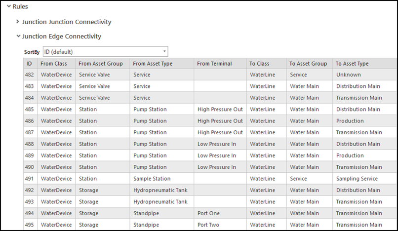
- Junction-edge connectivity rules declare the types of point features or junction objects that can be connected to edge features or edge objects. They also support connectivity to a device or junction with terminals, but they cannot be placed mid-span.
- Edge-junction-edge connectivity rules are based on geometric coincidence or connectivity associations. They control the types of lines or edges that can be connected to an intermediate junction. These rules are evaluated when you enable or validate network topology.
Structural Attachment Rules
Structural attachment rules restrict the types of features that can be attached to an asset type (structure) and they do not support terminal connectivity. These rules are created between structure features and attachment network features. Attachment network features can be from the device, junction, assembly, and structure junction feature classes, as well as junction and structure junction object tables. These rules are established at the asset group and asset type level, and they are enforced during edit operations.

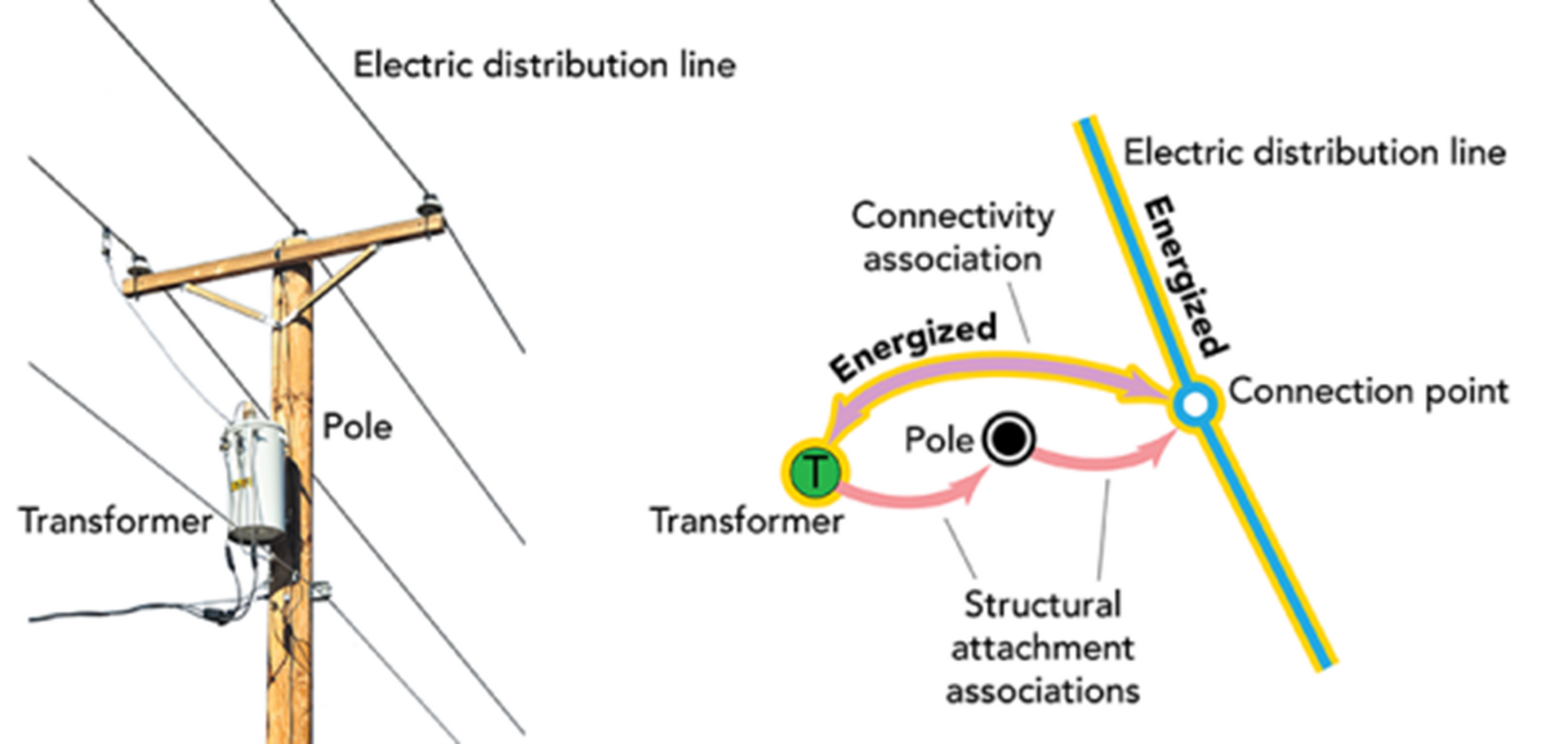
The image below is an example of a structural attachment. It shows a single-phase pole mounted electric transformer (attachment feature), the pole (structure feature), and connection point (attachment point). By creating features in a such a way, we enable network flow and traceability across data that is not directly connected - something the Geometric Network cannot do.
Containment Rules
Containment rules are new to the Utility Network, and they restrict the types of assets that can be contained in each asset type (container). This type of association enables the modeling of dense sets of assets while controlling map clutter. This rule type does not support terminal connectivity and is created at the asset group and asset type level.
The following are examples of containment associations:
- Pump houses versus the pumps and valves they contain,
- Electrical ducts versus the cables contained within,
- Electrical vault and the elbows or switches contained within.
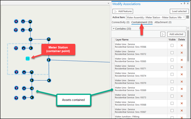
Below is an example of an asset-dense area of a water distribution system. In this example, the meter station point is the container, while the 33 assets at the station are captured and associated to the meter station point. It is also worth noting that the visibility of the assets can be toggled to reduce map clutter.
Network Rules are a comprehensive and complex component of the Utility Network, and this article has only scratched the surface. Esri’s Utility Network asset packages come with a base level of established rules, but each implementation of a Utility Network will require thoughtful planning and input from technical staff to engineers in order to arrive at - and grow - a powerful Utility Network-enabled corporate GIS.
Acorn Information Solutions (AIS) launched its MonARC Data Migration platform to help corporations implement or migrate to Utility Network. AIS has decades of experience in creating and administering municipal/utilities-based Geometric Networks combined with knowledge and experience in Utility Network migrations.
About the Author
Craig Martin is Acorn’s Municipal and GIS Manager and has over 25 years of experience in the field of GIS. Craig has extensive experience in data modeling, data capture, administration, solutions architecture, and smart data networks in a variety of engineering disciplines.
Connect with one of our experts at info@acorninfosolutions.ca.