

ArcGIS Utility Network: Introduction
Central to the evolution in modern GIS is Esri’s Utility Network. Utility Network is a framework of functionality for modeling complex utility systems such as electric, sewer, and water distribution. It is designed to model assets such as cables, pipes, valves, and transformers. You can also build real-world behaviour into the model.
With a Utility Network you can do the following:
- Detail how assets in a network are connected
- Intelligently trace the flow of a resource (water, sewage, electricity, etc.) through a network
- Analyze the real-world impacts to the network (equipment failure, storms, blockages, outages, etc.)
- Add, edit, and maintain assets in the network
- Create and share operational views of the network
- Create schematic network diagrams
Esri’s Utility Network is scalable and integrated with the ArcGIS platform so it can be accessed with applications such as ArcGIS Pro, Web Map Viewer, and ArcGIS Field Maps.
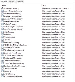
Many GIS-enabled organizations currently use Esri’s Geometric Network and are familiar with this technology. Utility Network is Esri’s next generation of GIS data network modeling and functionality, but it is significantly more complex and powerful than the Geometric Network. In the images below, we see a typical example of an Electric Distribution and Water Distribution Geometric Network. Layers are logically based on asset types with relevant attributes defined for each asset type. While data modeling techniques can vary, this is a very standard approach to asset modeling in GIS and will look familiar to GIS users and administrators.

In contrast to the Utility Network model shown below, while this model shows more than just feature classes, we should notice that the feature classes are contained in the ‘Domain Network’ section (outlined in red below). Note that instead of many layers based on asset types, we have the following five layers:
Device, Line, Junction, Assembly, Subnetline. The domain network contains the network features through which a resource is delivered
(sewer water, electricity, etc).
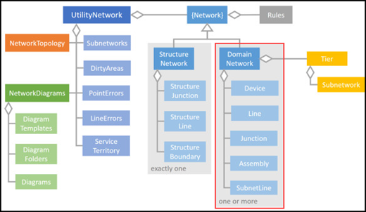
Lines are linear features that represent what a resource flows through (pipes, electrical cables, etc.) and can connect to other lines, junctions, or devices while being contained within assemblies.
Devices represent assets that control the flow of a resource (valves, pumps, hydrants, transformers, etc.) and can affect the resource in different ways. Device provide the option of having terminals set, which are entry points in the device. Devices can connect to lines and may be contained in assemblies.
Junctions are placed where lines connect to lines or lines connect to devices (elbows, reducers, taps, etc). Junctions allow devices or lines to connect to one another at an intermediate vertex, and they may also be contained in assemblies.
Assemblies are points that represent complex collections of other lines or points, and are useful in showing a single symbol on a map yet represent a complex collection and interaction of assets.
Subnetlines are linear features that define the extent of resource flow, and each subnetline represents a subnetwork. Subnetlines are an aid to visualization during editing, enabling the generation of subnetwork maps and summary information about the subnetworks.
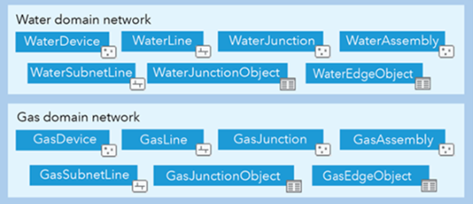
Every Utility Network will have these layers only. No matter how many layers or asset types your current GIS has modeled in a Geometric Network, they must be migrated into one of these layers (except the Subnetline layer - a special layer we will discuss in a future article). In our electric example above we see there are 25 feature classes that are modeled in the geometric network. A migration to Utility Network will require planning on correlating all 25 source layers into one of the four domain network layers.
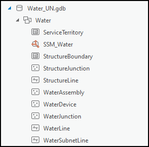
When staging a Utility Network, a descriptive name is applied
(ex. Water), and the features in the domain network will inheret this name, as shown below. Notice that features in a Utility Network are not named according to asset types
(fitting, manhole, pole, valve, etc.). Unlike the Geometric Network, all Utility Network features use a common naming convention.
Whether your organization is getting into Utility Network as your first GIS network, or if you are migrating from an existing Geometric Network, the process will be challenging. Proper planning, stakeholder engagement, and experience is critical to a successful Utility Network implementation or migration. Existing data holdings, functionality, and integrations will all need to be reviewed in order to determine a number of factors: what is required by the user base, which out-of-the-box solutions are available, what the proper data mapping between source and target layers will look like, and what the plan is for existing integrations with other software platforms.
GIS managers may view the Utility Network as a “software upgrade” to an existing GIS; however, this term may create the impression that an existing GIS simply undergoes a software managed process with the “new” GIS created as an output, like upgrading an operating system. At Acorn, we believe GIS decision makers should view the Utility Network as a new architectural implementation that includes comprehensive data review and migration, since there is currently no existing software-managed process that transforms the old GIS into the new GIS.
We will continue to break down the Utility Network in this series of articles – make sure to subscribe to our feed to be notified when upcoming articles are added. Acorn has successfully implemented many Geometric Networks in the electrical distribution, electrical transmission, drinking water distribution, sanitary sewer, storm sewer, and transportation sectors, and we have migrated Geometric Network data into the Utility Network.
Esri’s ArcGIS Enterprise changes the way corporations approach and operate a GIS. If your GIS was created prior to ArcGIS Enterprise, you will be required to migrate to this new platform in the future. Having a partner with extensive experience in both GIS software generations is critical to a successful migration. Acorn has launched its MonARC Data Migration solution to help GIS-enabled corporations navigate this critical and complex migration. We used our award-winning experience in municipal and utilities GIS to create this modular services solution.
About the Author
Craig Martin is Acorn’s Municipal and GIS Manager and has over 25 years of experience in the field of GIS. Craig has extensive experience in data modeling, data capture, administration, solutions architecture, and smart data networks in a variety of engineering disciplines. Connect with one of our experts at info@acorninfosolutions.ca