

ArcGIS Utility Networks: Subnetworks
Any municipality or utility that uses GIS will require knowledge of what Subnetworks are
Subnetworks are one of the major technological advancements in Utility Networks and any municipality or utility that uses GIS will require knowledge in what they are, how they work, and how they are maintained.
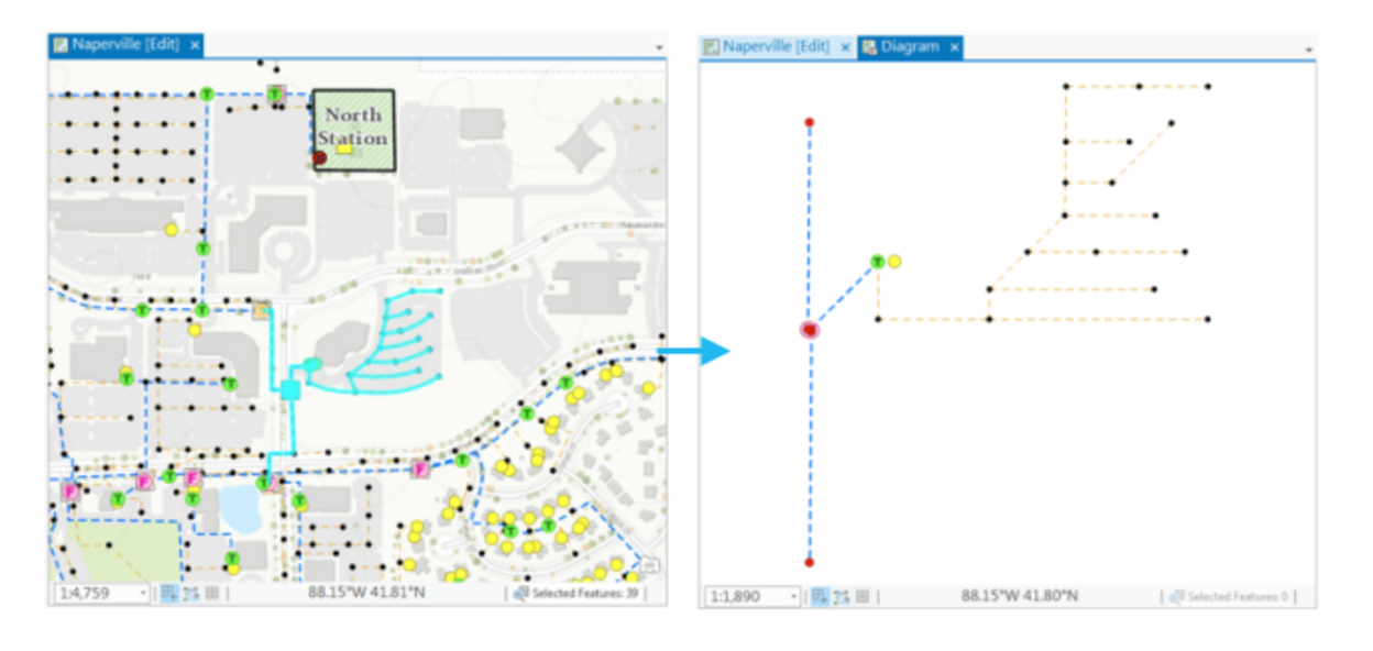
Subnetworks represent a data subset within a tier where all participating features have traceability to the same subnetwork controller. This subset is a collection of lines, devices, and junctions. Subnetworks drive tracing and network diagram events in order to visualize a network. Below we see a network trace results in ArcGIS Pro with a corresponding diagram view.
The following are examples of real-world resources that can participate in GIS a subnetwork:
- A municipality collects residential wastewater in a system of pipes then treats it through a variety of assets before discharging it back into the environment,
- A water utility acquires water through a variety of methods and then treats and distributes it to customers through a series of pipes,
- An electrical distribution utility receives electricity from a transmission network and then shapes that electricity in a collection of assets and cables as it is delivered to customers.
As we showed in one of our previous articles, each of these resources can be modeled into a domain network within a utility network. If we review the Utility Network architecture model, we can see where subnetworks reside and their relationship to other components.

In "ArcGIS Utility Network: Introduction" we discussed the structure of the domain network and how it contains all the utility network assets as either devices, lines, junctions, or assemblies. If devices are defined as subnetwork controllers, with terminals set properly, a subnetwork can be created (assuming it passes topological validation) and a new line will be created in the subnetline layer. Each line in the subnetline layer represents a subnetwork. Each subnetwork is managed by the editor as an individual entity (subnetline), as are the collection of assets used to create it (device, line, junction, assembly).
GIS users experienced with Geometric Networks will appreciate the degree of change detailed above. Whereas the Geometric Network provided network-based traceability analysis in an on-demand approach, the Utility Network has the traceable network defined, built and ready for analysis and consumption. Not only is this more efficient, but now the trace network is reachable by an expanded set of ArcGIS tools and products.
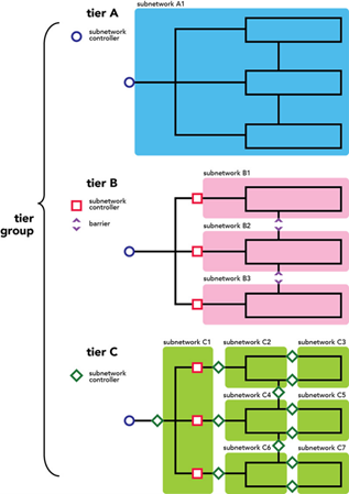
Another new technology in Utility Network are Tiers. Tiers represent a collections of individual networks that all share the same properties and restrictions. A Utility Networks tier definition is defined when creating the domain network in the Utility Network, so it is one of the primary and foundational steps.
A domain network can have one of the following tier definitions:
- Partitioned: supports networks that are sequential in nature (electrical, telecommunication, etc.)
- Hierarchical: supports networks that are nested (gas, water, etc.)
Features that reside in domain networks with a partitioned tier definition can only exist in one tier. Each tier is independent but certain assets may exist in one or more subnetworks as a delineator of the subnetwork (subnetwork controller).
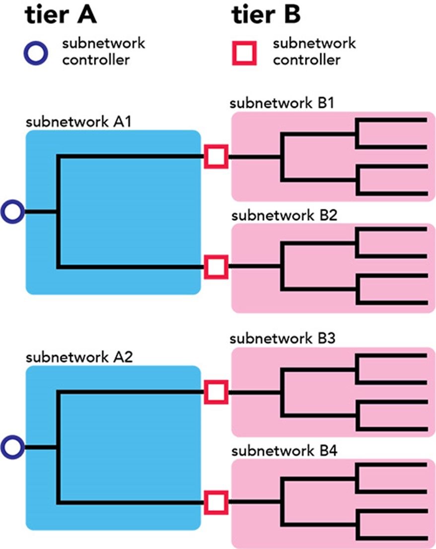
Features in domain networks with a hierarchical tier definition may exist in multiple subnetworks. The best illustration for this is a water distribution system, where we would expect to see subnetworks for the entire system, for pressure zones and for isolation zones. Assets may exist in one or all of these subnetworks.
The final component of subnetworks we will introduce is Topological Validation. We mentioned in a previous article that another significant advancement in Utility Network pertains to network rules. These are advanced rules that place requirements on data construction forcing adherence to defined standards. As GIS editors create data, or alter existing data, the Utility Network framework places a variety of rules on the editor, in order to achieve a high quality of data accuracy. The role of network topology is to enforce these various connectivity rules and flag any violations that will prevent a successful (re)build of the subnetwork impacted by the changes.
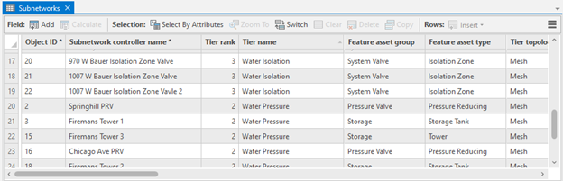
When the data that comprises a subnetwork change, the subnetwork needs to be updated to reflect those changes. This is not an automatic operation rather a work process that is managed by the data editor. The Utility Network framework provides an intuitive set of layers and symbols as part of this process, as shown below.
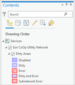
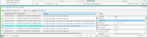
In addition to this layer and symbol set there is a table that can be viewed in ArcGIS Pro. The work process for the data involves iterations of validate > inspect > correct > validate, until there are no topological errors, at which point the subnetwork can be updated in a separate process.
Our article on subnetworks in the Utility Network has introduced several new GIS components and technologies with overview information. Each item we’ve discussed is a deeper subject matter in itself and worthy of a GIS user's continued education. Subnetworks are a critical part of a Utility Network and the work process involved in editing and maintaining them cannot be compared to a Geometric Network. We will continue to examine more of these components as our series of articles continue.
Acorn Information Solutions launched MonARC Data Migration platform to help corporations implement, or migrate to, a Utility Network. AIS has decades of experience in creating and administering municipal and utilities based Geometric Networks combined with knowledge and experience in Utility Network migrations.
About the Author
Craig Martin is Acorn’s Municipal and GIS Manager and has over 25 years of experience in the field of GIS. Craig has extensive experience in data modeling, data capture, administration, solutions architecture, and smart data networks in a variety of engineering disciplines. Connect with one of our experts at info@acorninfosolutions.ca